A woman in a red T-shirt crosses the floor of a temporary shelter in Escuintla, a green container in one hand and a bag of first-aid supplies in the other. Behind her, families lie on bright woven blankets, their bags, buckets, and water jugs gathered at their sides. Children leap between mattresses beneath an orange balloon.
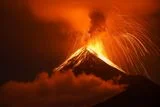
Outside, Fuego volcano erupts in Guatemala, spilling orange lava from its crater as ash churns above the mountain.
These were the scenes on Tuesday, Aug. 4, 2026, as captured in an Associated Press (AP) gallery.
The evacuation expanded to at least 18 communities and involved around 1,700 residents by Wednesday, according to AP reporting. Fuego’s stronger eruptive phase lasted roughly 50 hours before monitoring showed the volcano returning to its typical range, according to the National Coordinator for Disaster Reduction (CONRED).
Officials recorded no deaths or damage to buildings, but forecast rain could now transform freshly deposited volcanic material into hazardous mudflows called lahars.
Fuego Volcano Eruption Forces Evacuations Across Guatemala
The agency’s first evacuation bulletin reported that officials began moving people from El Porvenir and Las Lajitas on Aug. 3, 2026. Both communities sit within San Juan Alotenango, a municipality in the department of Sacatepéquez.
An official count the following day placed 1,522 people inside five shelters across Sacatepéquez and Escuintla. Inside the shelters, public agencies provided basic supplies, medical attention, and emotional support.
Ashfall disrupted life across Sacatepéquez, Escuintla, and Chimaltenango. The AP reported that authorities placed the three departments under red alerts, closed schools, and shut National Route 14, affecting about 29,000 people.
Read More: Kīlauea Volcano's Record-Breaking Lava Fountains Lasted for 9 Hours and Shot 650 Feet in the Air
Pyroclastic Flows Rush Down Fuego’s Slopes
Fuego is a 12,300-foot stratovolcano located about 33 miles from Guatemala City, according to the AP. Its slopes meet three departments in south-central Guatemala, and frequent eruptions make it one of Central America’s most active volcanoes.
The eruption reached its strongest stage by early Tuesday. An Aug. 4, 2026, government update, citing the country’s volcanology agency, traced pyroclastic flows into five drainage channels called Las Lajas, Honda, Seca, Taniluyá, and Ceniza.
Pyroclastic flows carry scorching gas and fragmented volcanic material across the ground at high speed. The same update warned that stronger activity could push the flows farther down the mountain, while winds could carry ash up to 62 miles west and northwest.
The AP put Tuesday morning’s lava fountains at roughly 984 feet high. Mudflows later reached 4.3 miles from Fuego, but officials had recorded no contact with villages or damage to buildings.
Rain Could Trigger Lahars After the Eruption Ends
Monitoring on Aug. 5, 2026, showed that Fuego’s intense 50-hour episode had ended. The volcano continued its baseline rhythm of four to six weak or moderate explosions per hour, according to CONRED.
Rain has now become the most pressing hazard. Water moving across the slopes can pick up ash, rocks, and other material deposited during the eruption. The resulting lahars may funnel through ravines toward roads, bridges, and communities below.
Some residents had begun returning home voluntarily by Wednesday. But emergency officials continued urging people to stay away from drainage channels, monitor local instructions, and remain ready to evacuate again.
The emergency response unfolded in the shadow of Fuego’s June 2018 eruption. According to the AP, the disaster left hundreds dead and destroyed an entire village, while affecting up to 1.7 million people.
For the families sheltering below Fuego this week, the volcano’s return to normal changes the nature of the danger without ending it. Their route home will depend partly on what the volcano does next and partly on how heavily the rain falls across the ash it left behind.
Read More: Mount Etna May Stem From a Rare Magma Mechanism, Explaining the Volcano's Puzzling Origins
Article Sources
Our writers at Discovermagazine.com use peer-reviewed studies and high-quality sources for our articles, and our editors review for scientific accuracy and editorial standards. Review the sources used below for this article:
- This article references information from the AP: Guatemala evacuates communities after Fuego volcano erupts, in photos
- This article references information from the AP: Fuego volcano spews more ash and mud as Guatemala shelters 1,700 who fled nearby villages
- This article references information from the AP: Fuego volcano activity that triggered evacuations in Guatemala is decreasing, but risks remain
- This article references information from CONRED: CONRED SYSTEM CARRIES OUT PREVENTIVE EVACUATIONS DUE TO ACTIVITY OF THE FUEGO VOLCANO
- This article references information from CONRED: CONRED SYSTEM PROVIDES ASSISTANCE TO FAMILIES SHELTERED DUE TO THE ACTIVITY OF THE FUEGO VOLCANO
- This article references information from CONRED: VOLCANO OF FIRE CONTINUES TO SHOW PYROCLASTIC FLOWS
- This article references information from CONRED: After 50 hours of activity, Fuego volcano returns to its normal parameters