- See more Daily Mail on Google - save us as a Preferred Source
Forget the sunscreen, now brollies and waterproofs might come in handy.
After five successive heatwaves brought devastating wildfires and drought conditions, the arrival of widespread rain could come as a much-needed relief.
But as torrential thundery showers make their way south across the country, drenching all but south-eastern areas, forecasters warn there could be flash flooding - because the ground is too hard to soak up the water.
The worst weather is forecast for Thursday, when heavy and thundery downpours are set to move south from Scotland.
Mike Silverstone, the Met Office’s deputy chief forecaster, warned: ‘As some of these showers could be intense, there is a chance of some surface water flooding as the rain falls on very dry and hard ground.’
He added: ‘While some of these will be heavy, some areas will miss them altogether.’
London and South East England, in particular, are likely to stay dry and sunny.
Temperatures over the coming days are due to reach highs in the low 20s Celsius (70s Fahrenheit) in southern England and Wales but only the high teens (60s F) in northern areas – more typical for a British summer.
A satellite image shows a largely brown and yellow-looking country last week
Rain could potentially cause flooding because the ground is hard and water cannot soak in
Thundery showers are likely to continue into Friday before a fine and dry Saturday.
Widespread rain first arrived late yesterday, spreading south-eastwards, followed by further showers today, particularly in northern areas.
Patchy drizzle is due to clear from the south east tomorrow morning followed by a return of sunshine in many areas.
Mr Silverstone said: ‘Many areas in England and Wales are desperate for rain, this week some of these areas will see the first meaningful rain for a long time.’
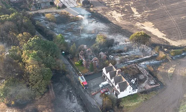
Wildfires destroyed 19 homes in Stourbridge, West Midlands, prompting an emergency alert
The prospect of further hot weather is not over yet, though – with ‘warm, humid spells’ possible through the rest of August and even another heatwave in September.
‘Largely dry and settled’ weather is likely over the weekend and into the first half of next week, although showers are possible in the far southeast and temperatures are not likely to rise above the 20s.
Unsettled conditions with ‘rain or showers’ and strengthening winds are predicted towards the Bank Holiday weekend.
But the Met Office has raised the spectre of a sixth heatwave before the autumn equinox - saying the first half of September could see ‘late season hot spells or heatwaves develop, especially in the south’.
The scorching conditions which have dominated Britain’s weather since May have seen drought conditions declared in two-thirds of England and all of Wales, turning parched fields yellow and draining reservoirs and water reserves.
More than 27 million people are now subject to restrictions on water use. Wessex Water was the latest company to bring in a hosepipe ban from today.
Last week saw the hottest day of the year with temperatures peaking at 38.1C (100.6F) on Thursday – close to the all-time record of 40.3C (104.5F) recorded in 2022 – sparking devastating wildfires including one which destroyed 19 homes in Stourbridge, West Midlands.
Tinder dry conditions have seen large blazes break out in countryside from the Peak District to the New Forest, South Wales and Suffolk – and resulted in the government issuing the first ever national emergency alert for wildfires to mobile phones last Friday.
July was the driest in England and Wales since records began 190 years ago and some areas recorded no rain for nearly two months, including Wisley, Surrey.