For many parts of the country, instructions for the weekend include tying down trampolines and keeping campervans home in preparation for strong winds and rain.
MetService has issued several wind and rain warnings for both the North and South Islands.
Meteorologist Alwyn Bakker said there was a series of fronts moving over the South Island from the southwest and bringing with it heavy rain and wind strength changes.
"Behind that front, kind of on the Sunday, we're getting strong, cold southwesterlies coming through.
"So what we're expecting wind wise, they're going to be very strong."
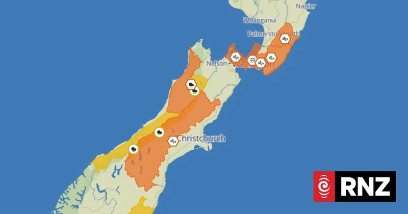
An orange strong wind warning is in place from very early on Sunday till the afternoon for Tararua District, Wairarapa, Canterbury High Country, Wellington and the Marlborough Sounds and Southland - south of Gore, including Stewart Island.
Dunedin and Clutha were under a yellow strong wind watch.
Bakker said in exposed areas there was a risk of severe westerly gales reaching 120 kilometres an hour - particularly for Southland.
"If you've got any items that can be picked up by strong winds, you should be preparing.
"Tie your trampolines down, that kind of stuff, and there's a risk of damage to trees and power lines and driving might be difficult, especially for campervans."
Bakker said heavy rain was less widespread than strong wind this weekend but still important.
An orange heavy rain warning was in place for the ranges of Buller and Grey Districts from 3pm Saturday till 9am Sunday.
Bakker said 90 to 120 millimetres of rain was expected over that time and thunderstorms were possible on Sunday morning. There was a minimal chance of upgrading to a red warning.
Yellow heavy rain watches were also issued for the headwaters of the Canterbury lakes and rivers and ranges of Westland District. The rain watches had a moderate chance of upgrading to a rain warning.
"Streams and rivers might rise rapidly, there might be surface flooding, there might be slips," Bakker said.
"We recommend before all of that comes through, just check your drains and gutters to make sure they're all clear."
While there are no snow warnings of any type, some snow was possible for higher roads in the South Island.
Bakker said the strong cold south westerlies expected would drag cooler air from the Southern Ocean. However, it was still unclear how well that would line up with the rain.
"Because there's no good whatsoever if you have lots of warm rain and then the cold air comes through afterwards. You won't get snow."
Bakker recommended that people check back again on Saturday for the latest warnings.
As for the upper North Island, it is currently free from any warnings and watches but that doesn't mean clear weather is expected.
"There's going to be a bit of rain for the upper North Island. It doesn't look anywhere near as heavy as it would be for Westland. Winds don't look too strong through there."
While the weekend is not looking good for most of the country, the beginning of next week is looking somewhat brighter.
"It's going to be another absolutely classic, the weekend is horrible and then it kind of goes all right for the work week.
"We're going to be getting a bit of a ridge building... so we've got a pretty minimal risk of anything happening Monday, Tuesday when it comes to severe weather."