A camping trip often begins with a map, some hiking routes, and a few promising places to pitch a tent. For amateur astronomer Joël Lapointe, however, planning a 2024 trip through northeastern Canada led to something far stranger — the discovery of a cosmic collision that occurred roughly 390 million years ago.
According to CBC News, while examining the Côte-Nord region of Quebec on Google Maps, Lapointe noticed an enormous circular indentation surrounding Lake Marsal. Spanning approximately 15.5 miles, the ring stood out against the surrounding landscape. To Lapointe, it looked suspiciously like a meteorite impact crater.
His hunch eventually reached planetary geologists, who made the difficult journey to investigate the site themselves. Their findings, which they will present at the annual congress of the Meteoritical Society, provided strong evidence that Lapointe had spotted a previously unidentified ancient impact crater hiding in plain sight.
How a Google Maps Discovery Led Scientists Into the Quebec Wilderness
Gordon Osinski, a planetary geology professor at Western University, regularly receives tips about possible craters through Impact Earth, his website dedicated to verified impact sites. Most of these reported discoveries do not survive scientific scrutiny. Circular geological features can form through volcanic activity, erosion, glaciation, and other processes unrelated to meteorites.
But Lapointe’s discovery looked promising enough to warrant a closer examination.
In 2025, Osinski and his team embarked on a five-day expedition to the remote site. Getting there proved almost as challenging as investigating the crater. According to the CBC, rugged, overgrown terrain prevented the team’s float plane from reaching shore, forcing the researchers to wade over 160 feet through the water while carrying their own equipment.
Once on land, they photographed the terrain and collected rock samples for analysis in laboratories in Canada and France. If upheld through the full scientific review process, the roughly 15.5-mile-wide structure would join only about 200 confirmed impact craters known worldwide.
The crater lies on the traditional lands of the Innu of Ekuanitshit, and researchers named it Uhackatik in consultation with the Innu Council of Ekuanitshit.
Read More: Meteorite That Crashed Into New Jersey Home Offers Chemical Clues on the Origins of Life
Shatter Cones Help Confirm a 390-Million-Year-Old Impact
A round shape alone cannot prove that a meteorite struck the ground. Scientists need geological evidence showing that rocks experienced pressures and temperatures far beyond those produced by ordinary Earth processes.
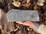
At Uhackatik, the researchers encountered large cliffs that appear to consist of impact melt rock, which forms when the heat of a collision melts part of the landscape. More decisive evidence arrived on the expedition’s second day, when the team located shatter cones.
Powerful shock waves create these distinctive, cone-shaped features, which occur almost exclusively at meteorite impact sites and underground nuclear explosion sites. Laboratory analysis of rocks formed during the collision allowed the team to date the structure to approximately 390 million years ago.
Other Surprising Discoveries Made With Google Earth
Uhackatik is far from the first remarkable feature noticed by someone exploring satellite imagery.
The CBC also reported on how Saskatchewan resident Lynn Hickox spotted Alberta, Canada’s “Badlands Guardian” while using Google Earth to search for the Royal Tyrrell Museum. The natural formation resembles a human head wearing a headdress, although thousands of years of erosion — rather than an ancient artist — created its appearance.
In 2009, Jay Wilbur used Google Earth to locate Fairy Bridge in China’s Guangxi Province, according to The Natural Arch and Bridge Society. The enormous natural formation is considered the world’s longest-known natural rock arch.
Google Earth also revealed unusual polka-dot patterns along the Grand Canyon’s North Rim. Green Matters reports that researchers now suspect colonies of red harvester ants created the circles by altering the vegetation around thousands of nests.
Together, these discoveries turn digital maps into more than navigation tools. Sometimes, looking closely at an ordinary screen is enough to uncover something extraordinary beneath our feet.
Read More: Lunar Meteorite Reveals Clues to 3.5-Billion-Year-Old Impacts that Struck Multiple Worlds
Article Sources
Our writers at Discovermagazine.com use peer-reviewed studies and high-quality sources for our articles, and our editors review for scientific accuracy and editorial standards. Review the sources used below for this article:
- This article references information from the CBC: He saw a pit on Google Maps. It turned out to be a 390-million-year-old meteor crater
- This article references information from the CBC: Atlas Obscura names Alberta's 'Badlands Guardian' curious, hidden wonder
- This article references information from Green Matters: Physicist Finally Solves the Mystery Behind Strange Polka-Dot Patterns Found in the Grand Canyon
- This article references information from Natural Arches: Fairy Bridge