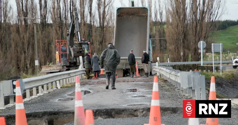
Destructive storms are exposing the vulnerability of rural communities, as ageing infrastructure and outdated river management are struggle to cope. In South Wairarapa, back-to-back floods have prompted difficult questions. As extreme weather becomes more frequent and severe, how can these communities adapt - and who will pay? Mary Argue and Baz Macdonald report.
Hands sinking into wet wool, James Bruce grabs another floating, lifeless ewe and turns towards the fence.
Wading through almost chest-deep water, he drags the drowned animal to the edge of the paddock where it joins the others.
Over and over again, the Martinborough farmer performs the grim task, until all 160 pregnant ewes are found.
The river just came up so fast, Bruce says.
"We.... got caught out a little bit. We got down here to shift stuff and it was too late.
"It was devastating. Don't even really want to talk about it, to be fair."
That June day was just the latest storm to smash into South Wairarapa this year - ripping up pasture, closing roads and repeatedly washing out bridges - and isolating hundreds of people and bringing businesses to a halt.
Data from the country's largest insurer underwriter, IAG, shows storm frequency doubled last year, with one hitting New Zealand every eight days on average.
South Wairarapa is just one of many such communities in Aotearoa grappling with hard choices.
As severe weather collides with ageing infrastructure, it is laying bare the gulf between rural regions' small ratepaying populations and their sprawling network of rivers and roads.
Scheme under scrutiny
Only a handful of sheep in Bruce's low-lying paddock survived the latest flood - the rest of the flock is now buried in a gravel-covered grave.
The loss of livestock is hard to take and the extensive damage also hurts.
Since buying the 500-hectare property almost two decades ago, Bruce and his partner have transformed it from five paddocks to about 40. The recent flooding is a major setback.
It will take two or three years of work to restore "shit that's been wrecked", he reckons.
South Wairarapa councillor and farmer Aidan Ellims says Bruce is not alone. Farmers across the region are struggling to find pasture for lambing ewes, with hilly paddocks scarred by slips and grass still buried in silt and gravel from the floodwaters.
In the aftermath of June's floods, which wiped out a rural lifeline bridge south of Martinborough for the second time this year, the regional council announced a review of the Lower Wairarapa Valley Development Scheme.
The washouts at Tūranganui Bridge on 17 February and 27 June isolated nearly 500 homes for days at a time, requiring quadbike runs over farmland and airdrops of basic supplies.
The more than 50-year-old flood protection scheme covers floodways, river management, and land drainage infrastructure for the district's rivers and lakes.
It is a "huge controlling mechanism", says Haami Te Whaiti. The current chair of the Wairarapa Moana Statutory Board, Te Whaiti has whakapapa connections to Wairarapa south coast hapū Ngāti Hinewaka, along with many of the Wairarapa Moana hapū (Ngāti Rakaiwhakairi, Ngāi Tūkoko, Ngāti Rākairangi, Ngāti Hinetauira, Ngāti Ngāpu o te Rangi).
The current system treats water as separate from nature, he says - something "to be drained, that needs to be controlled, it needs to just do what it's told basically". Instead, nature needs to be accepted to some degree, he says.
"We can't always protect ourselves from it by pushing against it."
Ngāti Kahungunu kaitiaki Rawiri Smith, who also has whakapapa links to Wairarapa Moana (Ngāti Muretu), says it is clear the current system has not worked.
"It hasn't protected the land and that's why we're sitting here talking about it. And so rather than saying, 'Well, actually, here's another engineering feat', what could a natural [one] look like?"
Solutions need to be staged over time, Smith says, balancing the needs of farmers - who are making a living - and the needs of the environment.
That might mean stop banks, he says. It might also mean farmers diversifying their business, converting some parts of their land to wetlands, and regional councils planting a variety of natives rather than just willows along river banks.
By some estimates, Wairarapa Moana has lost upwards of 90 percent of its wetlands, he says. These natural, water-retaining features not only reduce the impact of flooding but also improve water quality.
Wetlands occur naturally throughout a catchment, Smith says, mitigating the flow of water the entire way through. One wetland at one trouble spot will not stop the flooding, he says.
When the Tūranganui Bridge washed out, again, locals pointed the finger at the regional council and a perceived lack of gravel extraction.
Smith understands that position. In the short-term, removing rocks from different parts of the river might be part of the solution, but factors like bridge placement must be considered, too, he says.
"If the bridges are on the narrowest part of the waterway, where's the most stress? In a river, when it's full and overflowing, the most stress is at the narrowest point of the river."
The bridges had been designed for one-in-100-year storms - fine, Smith says, "until you get three 100 year floods in six months".
In the eastern hills of Martinborough, Ellims points to a frequently submerged stretch of White Rock Road as an example of a system that's not working.
Two weeks after a southerly dumped around 400mm of rain on Martinborough's eastern hills, piles of river gravel line the low-lying section of road next to the Awhea River.
"This metal has had to be cleared off the road to allow it to be passable for locals," he says.
"Ultimately, the locals are wanting the whole stretch of road from Tuturumuri back to Lagoon Hills - a few kays - to be increased in height, so that there's resilience and they can still get backwards and forwards from their farmhouses ... back into Martinborough."
The solution is staring them in the face, he says: use the river gravel to raise the road.
Greater Wellington Regional Council says a new approach to flood protection is needed in South Wairarapa - which accounts for about 20 percent of Greater Wellington's landmass but only 2 percent of its population.
Environment and Climate Committee chair and councillor Quentin Duthie says recent events have reinforced the need for a collaborative, long-term approach to flood protection.
It is clear work needs to be done around Tūranganui Bridge, he says - a lifeline connection for communities from Lake Ferry to Ngawi at Cape Palliser.
"Potential options could include changes to the bridge design, improvements to road approaches and potentially changes to the river channel itself," he says.
It is not just up to the regional council though. "These options need to be explored alongside South Wairarapa District Council, mana whenua and the local community."
The cost of connection
The washouts at Tūranganui had a direct economic hit on businesses south of the bridge.
John Priest, who runs Waimeha Camping Ground, estimates he lost about $20,000 in trade and refunds to guests who could no longer get there in February.
That scale of loss is not sustainable long-term, he says. Following the repeat washout four months later, he's now considering adding insurance or a non-refundable clause to guest bookings.
February's floods also closed a second lifeline bridge at the coast over Hurupi Stream - but even when the bridges are intact, the coastal Cape Palliser Road presents another challenge.
Pinched between steep hills and huge swells, the only road to and from Ngawi is battered from both sides. June's rainfall blewout multiple culverts, requiring ongoing partial road closures for repairs.
Until recently, the New Zealand Transport Agency (NZTA), has footed the entire maintenance and repair bill for Special Purpose Roads like Cape Palliser, which cater to high volumes of tourist traffic but have small rating populations.
Between 2021 and 2025, NZTA spent $2.5 million on maintaining and operating Cape Palliser Road, $2m on improvement projects and another $4.1m on emergency works for storm damage.
Since 2014, though, NZTA has been phasing out Special Purpose Roads, and Cape Palliser Road's designation comes to an end in mid-2027.
That prompted South Wairarapa mayor Fran Wilde to petition NZTA to secure an alternative funding arrangement, to avoid "the cost burden" falling squarely on ratepayers.
Locals say it is a vital link for the fisheries industry, and carries bumper-to-bumper tourist traffic to the famous lighthouse and seal colony.
Andrew Sim has fished in the area for more than 40 years. "Surely central government's got to look at that and look after us and keep us here."
Sim had been hedging his bets on what's driving the severe weather.
"I wasn't really into climate change or global warming, but the way this is stacking up there seems to be something happening," he says.
"I don't think I've ever had forecasts of 11m [swells] before - I brought most of my pots home for that one. Thank the Lord that I did. The rest I left out there took a beating."
A growing problem
What is happening in South Wairarapa is not unique. Infrastructure New Zealand chief executive Nick Leggett sees it as a warning shot for an impending nationwide problem.
"We've got a lot of bridges that were built in the middle of the last century and now many of them are approaching or exceeding the end of their design lives," he says. "That's because of higher river flows, more intense rainfall, more frequent weather events. That just accelerates the deterioration."
MetService data shows the wider Wairarapa region has been under four orange heavy rain warnings and one red severe rain warning so far this year.
Across the country, there are about 7700 bridges, Leggett says. They are owned by a multitude of councils and agencies, meaning there is no nationwide grasp on their condition.
"These bridges, like the one in South Wairarapa, will exist in different parts of the country. It's when they start to show themselves that will be the concern."
They are vital infrastructure in rural communities - for people, for essential services, and for getting goods to market - but their economic benefit can be taken for granted, he says.
"South Wairarapa is a real live example of what is going to be increasingly felt nationwide if we don't get on top of our bridge problem."
Finding a long-term fix
Standing at the road closure at Martinborough's Waihenga Bridge in July, South Wairarapa deputy mayor Rob Taylor is unequivocal, laying out what he believes is in store for rural communities nationwide.
"It's almost a national crisis currently. We get rain, sure - but it's the volume that we're now getting, we never got 450mm of rain in this region in the past. The 100-year floods, or the 100-year cycles that we built our infrastructure around is happening every other year."
The bridge - where State Highway 53 crosses the Ruamāhanga River - closes two to three times a year on average, NZTA says.
So far this year, three storms in April, June, and July, have shut the century-old bridge four times, with damaging floods in June lowering the threshold to close it.
Each closure hurts the community economically and psychologically, Taylor says. The "patch and mend" mentality needs to be left behind, he believes - it is time to replace the entire bridge.
"One day there'll be an event which might take the bridge out completely, and we'll all look at one another and say, 'Why didn't we fix it properly?'"
Earlier this month, the Climate Change Response Amendment Bill was introduced to Parliament, requiring councils to plan at least 30 years into the future, and spell out the likely cost.
South Wairarapa maintains about a 653km network of roads and bridges but with just under 7500 ratepayers, the district council simply can not afford repeated storm damage repairs, Taylor says.
"We're bigger than Auckland, but we have a roading team that's probably smaller than the company that cleans Mayor Brown's car.
"We have to have that conversation about how we adapt to climate change but the bigger question is - who's going to pay for it?"
Leggett says the lion's share of investment must be in bridge renewal, which returns "better bang for your buck," but he accepts that will not work for all bridges.
At current replacement rates, it would take 2000 years to get through the entire state highway bridge stock, an approach that is not sustainable, he says.
"It is going to take not just money and investment, but a really smart approach and understanding of the problem, and then a sequenced renewal, maintenance, and replacement regime. It's a national problem."
How to fund that is a big question and all options - such as private financing and borrowing more - should be on the table, he says.
Leggett estimates NZTA directs about 35 percent of its budget towards operations, renewal and maintenance, while countries like the United Kingdom and Sweden invest closer to 50 percent.
"In Australia asset preservation is fast becoming the priority before expansion. We need to adopt something similar here."
Leggett and Taylor say if infrastructure and climate adaptation aren't election issues already, they should be.
"Countries can change behaviour when they see a problem," Leggett says.
"New Zealand does traditionally find that harder. We're great at a crisis and we react in the moment and then everything goes back to peace time ... that's our challenge."
Election years can move the dial, he says. "This is the chance for voters to demand that."
Rawiri Smith says solutions to ageing infrastructure, severe weather, and flood protection don't have to work in opposition to each other. A middle-ground can be found.
"How do these all fit? They fit in a long-term plan. Now, how many people are willing to extend their thinking long-term? And that's our problem.
"If you only have a short-term plan, you only have one answer. If you think about that long-term, that's how you can weave all of these answers [together]."