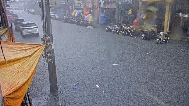
Sudden heavy rains in Cebu may continue through August — Pagasa
CEBU CITY, Philippines — Heavy afternoon and evening rains that triggered widespread flooding across Metro Cebu on Thursday may continue in the coming months as the rainy season peaks, even as forecasters expect El Niño to return and bring drier conditions before the end of the year.
The Philippine Atmospheric, Geophysical and Astronomical Services Administration (Pagasa) said Friday that Thursday’s nearly four-hour downpour, which inundated at least 16 communities across Cebu City, resulted from localized thunderstorms rather than a tropical cyclone or low-pressure area.
“It was an ordinary rain event caused by localized thunderstorms,” said Engineer Al Quiblat, chief of Pagasa-Mactan.
Quiblat said thunderstorms developed simultaneously over much of Metro Cebu, prompting Pagasa to issue heavy rainfall advisories as varying amounts of rain fell across the metropolis.
Rainfall monitoring from 1:30 p.m. to 3 p.m. Thursday showed 9 millimeters of rain at the Mactan rain gauge, while weather radar estimated 22.2 mm of rainfall over Cebu City and Mandaue.
Quiblat said the higher radar estimate reflected rainfall over a wider area, noting that localized thunderstorms often produce uneven rainfall distribution, with some communities receiving significantly heavier downpours than others.
He added that the nearly four-hour rain event qualified as an ordinary occurrence during the rainy season despite the flooding it caused because localized thunderstorms can produce intense rainfall over short periods.
He also ruled out the influence of the low-pressure area currently east of the country, saying its trough only began affecting the Visayas on Friday.
“Yesterday, it was purely a localized thunderstorm,” Quiblat said.
More afternoon rains expected in Cebu
Quiblat said residents should continue preparing for sudden heavy rains as July and August mark the peak of the country’s thunderstorm season.
“The rainy season runs from June to November. July and August are the peak months for thunderstorms, so we expect more frequent afternoon and evening occurrences compared with other months,” he said.
He explained that even without a tropical cyclone, the Intertropical Convergence Zone (ITCZ), a low-pressure area, could still produce intense thunderstorms that rapidly develop and dump large volumes of rain over localized areas.
“There’s always a high chance of thunderstorms forming within the day that can bring sudden heavy rainfall,” Quiblat said. “Sometimes, cumulonimbus clouds develop quickly, producing intense downpours.”
The weather bureau’s Visayas Regional Services Division forecast cloudy skies with scattered rain showers and thunderstorms across Metro Cebu and the rest of the province on Friday due to the trough of the low-pressure area.
Light to moderate winds from the northwest to southwest and slight to moderate coastal waters will also prevail.
LPA unlikely to become storm
While Pagasa continues to monitor a low-pressure area outside the Philippine Area of Responsibility (PAR), Quiblat said current assessments indicate a low probability that it will develop into a tropical cyclone.
The weather system could enhance the southwest monsoon if it moves closer to the Philippines, but he said forecasters expect it to remain weak and eventually dissipate.
“Even if it enters the PAR, it is unlikely to move close to land,” Quiblat said. “Its trough or cloud extension is what we’re experiencing now.”
Because of this, Metro Cebu may continue to experience light to moderate rains, with localized thunderstorms capable of producing heavier downpours during the afternoon and evening.
Dry spell persists despite rainy season
Although Pagasa declared the onset of the rainy season in June, Cebu has continued to experience below-normal rainfall over the past three months, Quiblat said.
He explained that the classification comes from rainfall data collected across multiple weather stations and analyzed by Pagasa’s Climatology Division rather than from a single monitoring site.
“We recorded below-average rainfall in May, June, and July,” he said.
Those three consecutive months of below-normal rainfall led meteorologists to classify the condition as a dry spell despite the official onset of the rainy season.
However, Quiblat said rainfall should improve over the next few months, with August through October expected to receive near-normal precipitation.
El Niño expected by November
Pagasa also warned that the effects of El Niño could begin affecting the Philippines by November after the climate pattern strengthened over the eastern and central Pacific Ocean.
Quiblat said the agency had already issued an El Niño advisory as forecasters expect rainfall to drop below normal toward the end of the year.
“The impact of El Niño is expected to begin in the Philippines around November and December,” he said.
For Cebu, Pagasa forecasts below-normal rainfall from November through January, raising the possibility of another dry spell by the end of January if rainfall deficits persist.
The outlook means Cebu could shift from frequent rain events during the peak of the rainy season to significantly drier conditions within the next several months.
The forecast comes a day after heavy rains submerged major roads across Cebu City, stranded commuters, forced emergency rescues, disrupted traffic, and inundated at least 16 barangays, underscoring the city’s continued vulnerability to short-duration but intense rainfall events.
Disclaimer: The comments uploaded on this site do not necessarily represent or reflect the views of management and owner of Cebudailynews. We reserve the right to exclude comments that we deem to be inconsistent with our editorial standards.