LPA inside PAR has ‘medium’ chance of becoming tropical cyclone
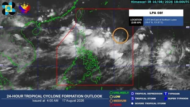
CEBU CITY, Philippines — A low-pressure area (LPA) inside the Philippine Area of Responsibility (PAR) had a “medium” chance of developing into a tropical cyclone, the state weather bureau said Monday, August 17.
In its daily forecast, the Philippine Atmospheric, Geophysical and Astronomical Services Administration (Pagasa) said the LPA had not directly affected the country’s weather conditions this Monday morning.
As of 3 a.m., the LPA was located 1,040 kilometers east of Northern Luzon.
READ: Class suspensions on Aug. 17 (Monday) due to habagat
Pagasa said the system was forecast to move westward and cross Extreme Northern Luzon in the coming days.
If the LPA develops into a tropical cyclone while inside PAR, it will be assigned the local name “Neneng.”
Habagat prevails
Meanwhile, the southwest monsoon, or habagat, would continue to bring rains over Luzon and the western sections of the Visayas over the next five days, Pagasa said.
Heavy rainfall of 50 to 100 millimeters may affect Ilocos Sur, La Union, Pangasinan, Benguet, Zambales, and Bataan on Monday.
Similar rainfall conditions are expected on Tuesday in Ilocos Sur, La Union, Benguet, Pangasinan, Zambales, Bataan, Tarlac, Pampanga, Bulacan, Metro Manila, Cavite, Batangas, Occidental Mindoro, and Antique.
Isolated rains over Visayas, Mindanao
The rest of the Visayas and Mindanao would generally experience fair weather, although localized rains or thunderstorms may still occur, the bureau said.
Several areas are also expected to experience high temperatures on Monday.
Cebu and Tacloban may reach 34 degrees Celsius, while temperatures in Zamboanga may rise to 35 degrees Celsius.
As of Monday morning, Pagasa had not issued a gale warning over any of the country’s seaboards.
Disclaimer: The comments uploaded on this site do not necessarily represent or reflect the views of management and owner of Cebudailynews. We reserve the right to exclude comments that we deem to be inconsistent with our editorial standards.