10 Luzon areas under Signal No. 1 as TD Luis maintains intensity
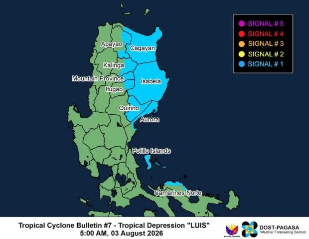
MANILA, Philippines — Tropical Cyclone Wind Signal (TCWS) No. 1 remained in effect over 10 areas in Luzon on Monday as Tropical Depression Luis continued to maintain its strength, the state weather bureau said.
In its 5 a.m. bulletin, the Philippine Atmospheric, Geophysical and Astronomical Services Administration (Pagasa) said the following areas are under TCWS No. 1:
- The central and eastern portions of Cagayan (Enrile, Tuguegarao City, Peñablanca, Piat, Santo Niño, Camalaniugan, Tuao, Lal-Lo, Gonzaga, Alcala, Amulung, Santa Teresita, Baggao, Buguey, Solana, Rizal, Santa Ana, Gattaran, Iguig, Lasam, Aparri, Ballesteros, Abulug, Allacapan, Pamplona)
- Isabela
- Quirino
- The eastern and southern portions of Apayao (Flora, Santa Marcela, Conner, Pudtol, Luna)
- The eastern portion of Kalinga (City of Tabuk, Tanudan, Pinukpuk, Rizal)
- The eastern portion of Mountain Province (Paracelis, Natonin)
- The eastern portion of Ifugao (Aguinaldo, Alfonso Lista)
- The northern portion of Aurora (Dinalungan, Casiguran, Dilasag, Dipaculao, Baler)
- Polillo Islands
- The northern portion of Camarines Norte (Daet, Talisay, Paracale, Jose Panganiban, Capalonga, Vinzons)
Last located at 130 kilometers east-southeast of Casiguran, Aurora, Luis maintained its strength, packing a maximum sustained wind speed of 55 kilometers per hour (kph) near the center and gusts of up to 70 kph.
The tropical depression moves almost stationary, Pagasa said.
Luis is forecast to move generally northwestward and may make landfall or pass close to Northern Luzon this Monday evening or early morning on Tuesday.
Afterwards, the tropical depression would then “sharply turn east-northeastward while moving away from the Philippine landmass.”
Pagasa also said Luis is forecast to remain a tropical depression over the majority of the forecast period and may be downgraded into a remnant low-pressure area by Wednesday “before becoming fully assimilated into the circulation of Tropical Cyclone Dolphin.”
Meanwhile, Typhoon Dolphin was last located 2,850 kilometers east-northeast of extreme northern Luzon outside the Philippine area of responsibility (PAR).
It has a maximum sustained wind speed of 155 kph and gusts of 190 kph, moving west-northwestward at 25 kph.
Pagasa said Dolphin remains far from the landmass, thus, still having no direct effect on any part of the country.
The weather bureau said there is still a low chance that the typhoon will enter the PAR.
Disclaimer: The comments uploaded on this site do not necessarily represent or reflect the views of management and owner of Cebudailynews. We reserve the right to exclude comments that we deem to be inconsistent with our editorial standards.