Your support helps us to tell the story
From reproductive rights to climate change to Big Tech, The Independent is on the ground when the story is developing. Whether it's investigating the financials of Elon Musk's pro-Trump PAC or producing our latest documentary, 'The A Word', which shines a light on the American women fighting for reproductive rights, we know how important it is to parse out the facts from the messaging.
At such a critical moment in US history, we need reporters on the ground. Your donation allows us to keep sending journalists to speak to both sides of the story.
The Independent is trusted by Americans across the entire political spectrum. And unlike many other quality news outlets, we choose not to lock Americans out of our reporting and analysis with paywalls. We believe quality journalism should be available to everyone, paid for by those who can afford it.
Your support makes all the difference.
Read more
The Gulf Coast is on alert as Tropical Storm Bertha churns toward populated areas, threatening flooding rain, dangerous storm surge and damaging wind gusts, while Hurricane Fausto has strengthened in the eastern Pacific but poses no immediate threat to land.
Bertha, the second named storm of the Atlantic hurricane season, formed Monday evening and was about 140 miles (225 kilometers) south of Panama City, Florida. The storm had maximum sustained winds of 40 mph (65 kph) and was expected to strengthen as it edges toward the northern Gulf Coast, according to the National Hurricane Center in Miami.
Forecasters warned the slow-moving storm could linger near the coast for days, raising the risk of prolonged heavy rain, flash flooding and coastal inundation from Florida to Louisiana before drifting west toward Texas.
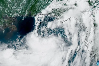
A satellite view of Tropical Storm Bertha forming over the eastern Gulf of Mexico near Florida (Reuters)
By Monday night, Bertha was nearly stationary but was forecast to turn west or west-northwest over the next several days.
A tropical storm warning is in effect from the Alabama-Florida border west to southeastern Louisiana, while a storm surge watch stretches from the mouth of the Mississippi River to the Alabama-Florida border.
The hurricane center warned that life-threatening storm surge of up to 4 feet (1.2 meters) is possible in parts of Louisiana, Alabama and Florida. Bertha could also spawn isolated tornadoes across Florida's Big Bend.
This satellite image from the National Oceanic and Atmospheric Administration taken at 7:31pm EDT shows Tropical Storm Bertha in the Gulf of Mexico (AP)
Forecasters said flash flooding is possible through Friday from western Florida to central Texas. Louisiana could see 3 to 5 inches (7 to 12 centimeters) of rain, with isolated areas receiving significantly higher totals.
Communities are already preparing for the storm. Red flags flew along the beach in Orange Beach, Alabama, warning swimmers of dangerous surf and rip currents, while emergency officials in Florida's Escambia County distributed sand to residents filling sandbags in flood-prone neighborhoods.
Farther west, Hurricane Fausto strengthened Monday night about 745 miles (1,200 kilometers) southwest of the southern tip of Mexico's Baja California peninsula.
Fausto had maximum sustained winds of 75 mph (120 kph) and was moving west-northwest at 9 mph (15 kph). No coastal watches or warnings were in effect, but forecasters warned the hurricane could generate dangerous surf and life-threatening rip currents along parts of the Baja California coast.