Scientists have provided an update on the Super El Niño – and say the terrifying climate pattern is 'evolving'.
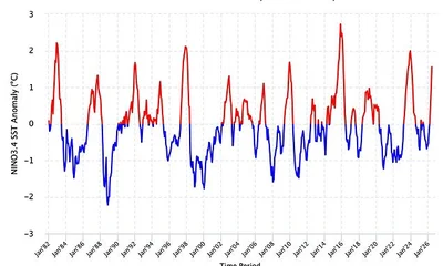
New measurements show that El Niño conditions are strengthening across the tropical Pacific, with sea surface temperatures (SST) showing a steady upward trend.
From April to June, the sea surface in this region was around 0.98°C above average, according to scientists from Columbia University.
By June, this had increased to 1.55°C above average.
And on 15 July, it climbed even further, with SST reaching 2.1°C above average.
'Together, these Pacific Ocean SST observations indicate that El Niño conditions continue to intensify, suggesting the event is evolving toward a very strong El Niño,' the researchers explained.
Worryingly, the experts say that the worst is yet to come.
Their analysis predicts that El Niño conditions will strengthen further during 2026 – and could even persist into early 2027.
New measurements show that El Niño conditions are strengthening across the tropical Pacific, with sea surface temperatures (SST) showing a steady upward trend
In their latest update, the researchers looked at both oceanic and atmospheric indicators of El Niño.
While oceanic indicators include sea surface temperatures, atmospheric indicators focus on the Southern Oscillation Index (SOI), which measures the sea–level pressure difference between Tahiti and Darwin, Australia.
According to the data, SOI was –24.9 in June, before dropping even lower to –30.0 by 18 July.
'These persistently negative SOI values reflect a further weakening of the Walker circulation, consistent with continued El Niño development and intensification,' the team explained.
Looking ahead, the models show that the probability of El Niño persisting through until March are 100 per cent, while there's a 94 per cent chance the climate pattern will remain in place until May.
So, what does this mean for us?
According to the World Meteorological Organisation, we can expect above-normal temperatures in 'nearly all parts of the globe' this summer.
The strongest heat signals are forecast across southern and western North America, Central America, the Caribbean, Europe, North Africa, and much of Asia.
Looking ahead, the models show that the probability of El Niño persisting through until March are 100 per cent, while there's a 94 per cent chance the climate pattern will remain in place until May
Northern parts of Asia may also be warmer than usual, although the forecast there is less certain.
In the Southern Hemisphere, warmer-than-normal conditions are also expected across many areas.
Northern South America is likely to see the strongest warming, while Southern Africa is forecast to experience widespread above-normal temperatures.
In Australia, warmer conditions are mainly expected along the western, southern, and eastern coasts, with no clear trend in the north.
Tropical regions around the world are also forecast to be hotter than normal, especially Equatorial Africa and parts of Southeast Asia and the Maritime Continent.
However, looking ahead, the Met Office predicts the El Niño could cause a cold and wet winter for Brits.
'Its impacts here in the UK are typically indirect, but it can increase the likelihood of more unsettled conditions later in the year, including a higher chance of milder, wetter and windier weather during autumn and early winter,' it explained.
'El Niño can also be associated with colder and calmer late winter periods in the UK.'
El Niño and La Niña are the warm and cool phases (respectively) of a recurring climate phenomenon across the tropical Pacific - the El Niño-Southern Oscillation, or 'ENSO' for short.
The pattern can shift back and forth irregularly every two to seven years, and each phase triggers predictable disruptions of temperature, winds and precipitation.
These changes disrupt air movement and affect global climate.
ENSO has three phases it can be:
- El Niño: A warming of the ocean surface, or above-average sea surface temperatures (SST), in the central and eastern tropical Pacific Ocean. Over Indonesia, rainfall becomes reduced while rainfall increases over the tropical Pacific Ocean. The low-level surface winds, which normally blow from east to west along the equator, instead weaken or, in some cases, start blowing the other direction from west to east.
- La Niña: A cooling of the ocean surface, or below-average sea surface temperatures (SST), in the central and eastern tropical Pacific Ocean. Over Indonesia, rainfall tends to increase while rainfall decreases over the central tropical Pacific Ocean. The normal easterly winds along the equator become even stronger.
- Neutral: Neither El Niño or La Niña. Often tropical Pacific SSTs are generally close to average.
Source: Climate.gov