Your support helps us to tell the story
From reproductive rights to climate change to Big Tech, The Independent is on the ground when the story is developing. Whether it's investigating the financials of Elon Musk's pro-Trump PAC or producing our latest documentary, 'The A Word', which shines a light on the American women fighting for reproductive rights, we know how important it is to parse out the facts from the messaging.
At such a critical moment in US history, we need reporters on the ground. Your donation allows us to keep sending journalists to speak to both sides of the story.
The Independent is trusted by Americans across the entire political spectrum. And unlike many other quality news outlets, we choose not to lock Americans out of our reporting and analysis with paywalls. We believe quality journalism should be available to everyone, paid for by those who can afford it.
Your support makes all the difference.
Read more
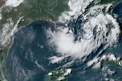
A tropical depression drifting erratically in the northern Gulf of Mexico is expected to strengthen later Monday with rain that could trigger flooding and winds capable of downing trees and power lines in several states this week.
The depression was centered about 110 miles (180 kilometers) south of Panama City, Florida, with sustained winds of 35 mph (55 kph). It was poised to gradually strengthen and reach tropical storm status later in the day, the U.S. National Hurricane Center said.
The Miami-based center said the system was roughly moving toward the northwest near 3 mph (6 kph) and is expected to move near or along the northern Gulf Coast over the next several days, prompting a storm surge watch extending from the mouth of the Mississippi River to the Alabama-Florida border on the Gulf Coast.
A tropical storm watch also was posted from the Ochlockonee River in Florida westward to southeastern Louisiana at the Jefferson and Plaquemines parish line.
The National Weather Service office in New Orleans said storm conditions may set in from the Florida Panhandle westward into Louisiana by Tuesday. It warned of wind gusts of 40 mph (60 kph) and noted a possible “life threatening" storm surge watch for the Alabama, Mississippi and southeastern Louisiana coasts.
Storm surges of up to four feet (1.2 meters) could occur in portions of the Louisiana and Mississippi coastlines, the hurricane center said, warning there also could be an isolated tornado or two possible over the Florida Big Bend region this week.
Areas of flash flooding will also be possible through Friday along the coast, from western Florida to middle Texas, the weather service said. It added that rainfall could reach 3 to 5 inches (7 to 12 centimeters) along the Louisiana coastline with higher amounts expected in some areas, notably south of Lake Pontchartrain.